
Navigating Cadastral Approvals and Geomatics Compliance in South Africa
Finding the correct surveyor general contact details is the first step in ensuring your land development or mining project remains on schedule. As the ultimate gatekeeper of land rights in South Africa, the Surveyor General (SG) office is responsible for examining and approving all survey records to maintain the integrity of the nation’s property registry.
At Trail Surveys, we serve as a professional link between technical field data and official government approval, navigating the complexities of the SG’s requirements so you don’t have to.
National Surveyor General Office Directory (2025 Verified)
LiDAR uses rapid laser pulses to map the environment, creating a “point cloud” that consists of millions of data points.
- Best for: Large-scale topographic surveys, heavily wooded areas, and complex infrastructure like power lines or bridges.
- The Advantage: LiDAR can “see” through vegetation to capture the true bare earth (DTM), which is nearly impossible for traditional methods or standard aerial photography.
- Efficiency: Mapping a 50km road corridor that would take weeks with a Total Station can be completed in days—or even hours—using UAV LiDAR or Mobile Scanning.
2. The Case for Traditional Surveying: Precision and Detail
As of May 1, 2025, cadastral documents must reflect the updated names of Deeds Registries (e.g., “North Gauteng” or “South Gauteng”). Below is the verified directory for regional SG offices.
Office / Province | Verified Street Address | Telephone | Data Request Email |
Gauteng (Pretoria) | 610 Lilian Ngoyi St, Pretoria Central | 012 312 8911 | sgdatagp@dlrrd.gov.za |
Western Cape | Revenue Building, 90 Plein St, Cape Town | 021 465 7358 | sgdatawc@dlrrd.gov.za |
KwaZulu-Natal | 300 Pietermaritzburg St, PMB | 033 355 2900 | sgdatakzn@dlrrd.gov.za |
Limpopo | 101 Dorp Street, Polokwane | 015 495 1988 | sgdatalmp@dlrrd.gov.za |
Mpumalanga | 14 Henshall Street, Nelspruit | 013 754 5400 | sgdatampu@dlrrd.gov.za |
Free State / N. Cape | 73 Aliwal Street, Bloemfontein | 051 448 0955 | sgdatabfn@dlrrd.gov.za |
Eastern Cape | 11 Phillip Frame Road, East London | 043 783 1400 | sgdataec@dlrrd.gov.za |
North West | 3139 Sekame Street, Mmabatho | 018 388 7095 | sgdatanw@dlrrd.gov.za |
Core Documents for SG Submission
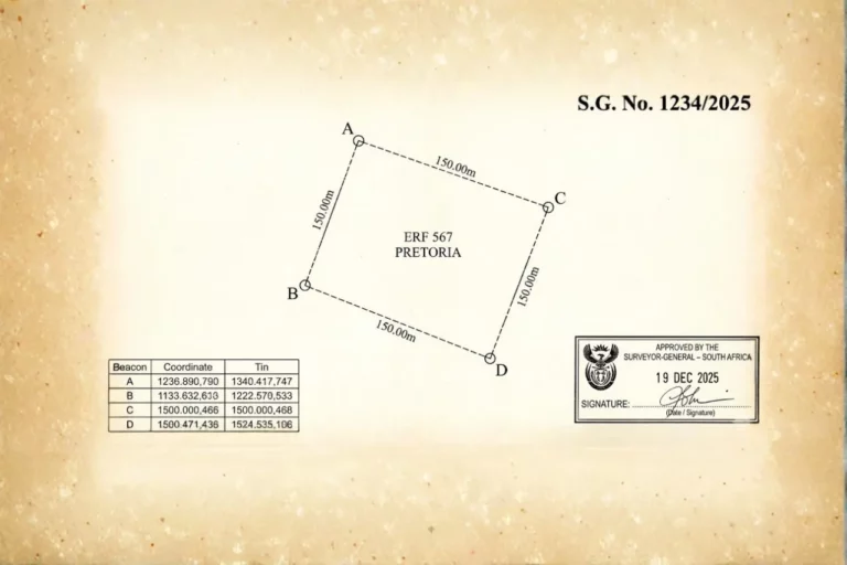
Every land survey document is a legal registerable record that must depict specific data, including unique property designations, boundary descriptions, and numerical coordinate tables.
- Cadastral Diagrams: The fundamental document defining a property’s legal extent.
- General Plans (GP): Required for new townships or large subdivisions (e.g., 2 to 50+ erven).
- Sectional Title Plans: Plans for separate ownership within buildings, requiring certification of town planning compliance.
- Servitude & Lease Diagrams: Necessary for registering rights like powerlines (Eskom) or long-term leases over portions of land.
- Mining & Mineral Diagrams: Essential for registering the legal right to extract minerals separately from surface land rights.
The Digital Lodgement Revolution
The Chief Surveyor General has prioritized Digital Lodgement to reduce examination periods and improve data accessibility.
- Speed: Digital submissions remove the need for physical printing and courier delays, allowing for faster acknowledgments via email.
- Cost Efficiency: Practitioners no longer need to use expensive transparent films or large-scale plotters for initial lodgement.
- Verification: Advanced software allows for quicker automated verification of numerics (coordinates, sides, and areas) before a human examiner reviews the final plan.
Why Submissions Get Rejected: Common Pitfalls
Even minor errors can cause the SG to reject a submission, leading to significant project delays. Common issues include:
- Lack of Professional Certification: Plans must be signed by a registered Professional Land Surveyor. Submissions from non-qualified agents are frequently sent back.
- Inconsistent Planning Consent: If the wording of a municipal consent letter differs from the layout plan, the SG may refuse approval to ensure the diagram remains registrable in the Deeds Office.
- Incomplete Survey Records: Missing field observations, working plans, or land surveyor reports are grounds for immediate rejection.
- Use of Improper Materials: General plans must be submitted on specific suitable materials; “white film,” for example, is not accepted for archival purposes.
Professional Fees & Administrative Costs (Guideline Only)
The SG charges specific fees for examining plans, which are periodically adjusted via the Government Gazette.
- General Plan (2-50 pieces): Basic fee starts at approximately R1,330, plus an additional fee per piece of land.
- Sectional Plan: Basic fee is roughly R480, plus additional fees for each newly created section or exclusive use area.
- Re-submission Fee: If a plan is rejected and must be re-lodged, a separate administration fee (approx. R85) often applies.
Conclusion: Trusting Trail Surveys for Professional Liaison
Navigating the Surveyor General’s requirements demands a blend of technical accuracy and regulatory insight. At Trail Surveys, we specialize in the meticulous drafting and submission of cadastral records, ensuring your property or mining rights are secured without unnecessary delays.
By leveraging our expertise in Digital Lodgement and our deep understanding of the Land Survey Act, we provide the legal certainty your infrastructure projects require. For further technical insights, visit our detailed guides on Working with the SG Office and The Role of the Surveyor General.

How can we help you?
Trail Surveys offers comprehensive land surveying, topographic mapping, and geomatics solutions across various sectors. Contact us today via phone, email, or our website, and one of our expert surveyors will promptly get in touch for a personalized consultation.